
Let’s go to the HippoHop: Mining Yelp Data for Relationships and Points of Interest
Parks, pubs, cafes, religious institutions, community centers, and bookstores support events and serendipitous interactions that let people meet, have experiences, form memories, and perform activities together. But does the city have a place for you to hang out with your aunt? Your co-worker? Your friend’s small children?
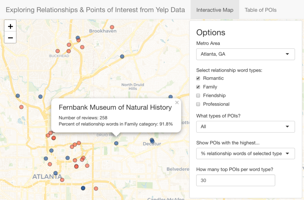
In this work, we show which points of interest (POIs) provide experiences for social life and personal relationships. We mine reviews about POIs from the online crowdsourcing review site Yelp via the Yelp Open Dataset. For example, a review may say “I came to Sam’s Restaurant with my mother and we had a great time!” Using basic natural language processing we mined through thousands of reviews to find out what places mentioned what kinds of relationships.
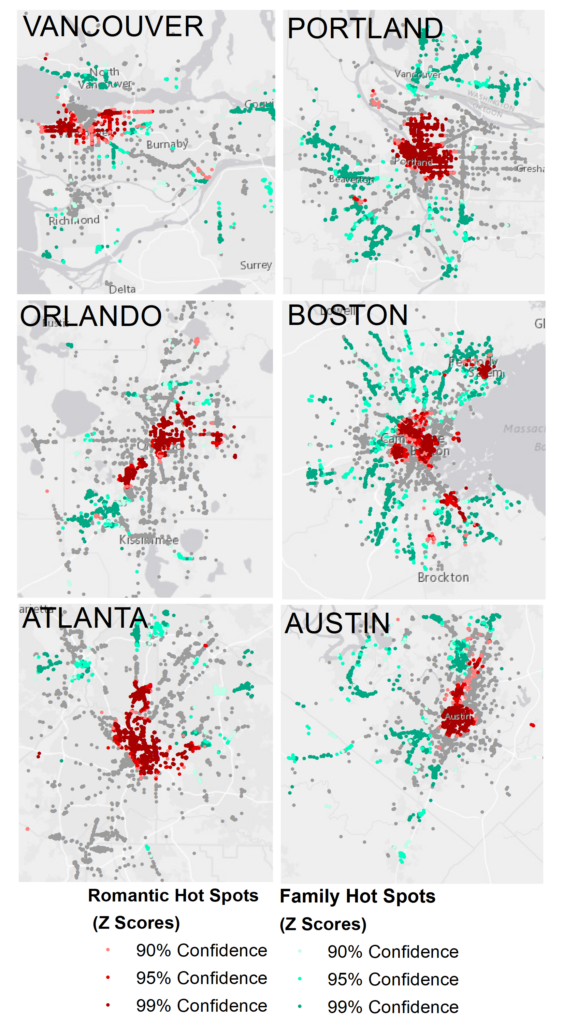
For every 1,000 Yelp reviews we find 150+ relationship words! When we map the words we find that romantic relationships are often located in downtown areas, while reviews referencing children are dispersed in suburban areas; professional relationships tend to be concentrated downtown and, in some cases, near universities. See the scientific paper here. This work was presented at URBCOMP ’22.
The analysis covers Atlanta, GA; Austin, TX; Boulder, CO; Boston, MA; Columbus, OH; Orlando, FL; Portland, OR; and Vancouver, BC. Check out our interactive tool to explore!
Estimating Diversity at Points of Interest (POIs) in Atlanta, Georgia using Origin-Destination Trip Data
By Seolha Lee
Segregation in cities has led to disinvestment and inequality in education, public health, and other opportunities, and a potential lack of social mixing across the city. However, residential segregation is only one part of segregation in a city. The location of jobs and third places (i.e. points of interest (POI)) may also perpetuate a lack of mixing among populations of different races, ethnicities and income groups. Analysis of individuals’ activity spaces shows that segregation is not just residential, but that activity spaces are segregated as well (Farber et al., 2015; Wang et al., 2018). Furthermore, segregation of activity spaces can be more intense than expected by residential geographic segregation (Dong et al., 2020), and perhaps explained by residents forgoing nearby POIs for more socially and culturally-attractive POIs (Arentze & Timmermans, 2008; Etminani-Ghasrodashti & Ardeshiri, 2015).
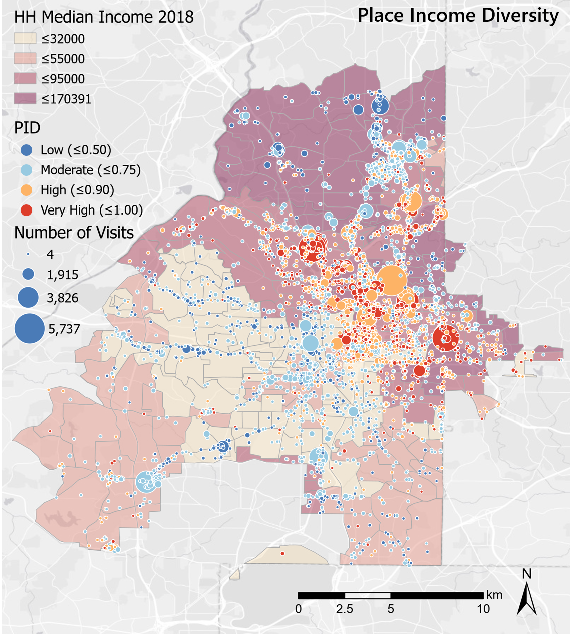
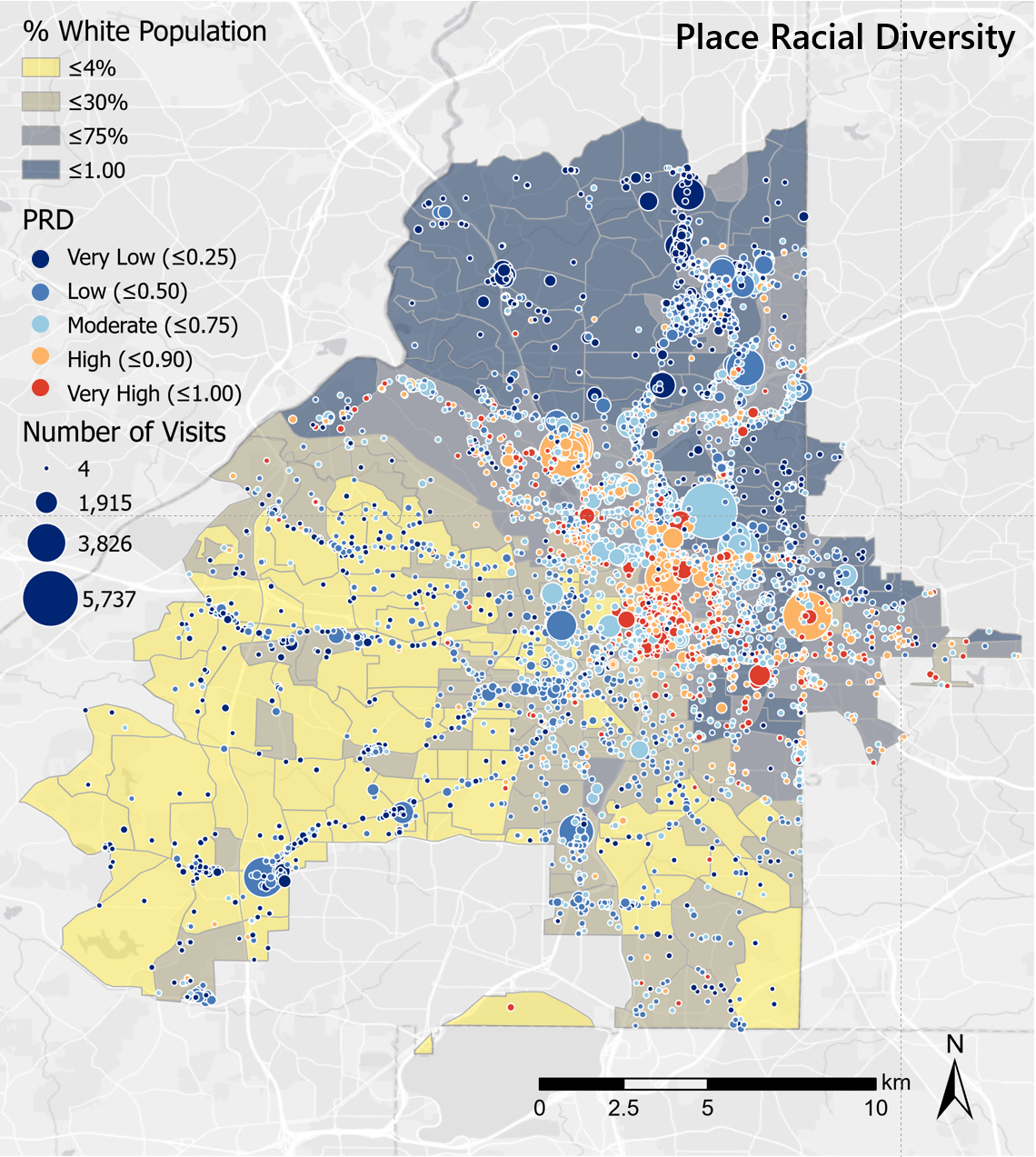
In this research, we ask which kinds of POIs (by neighborhood location and by category) have a more diverse set of visitors, defined as the proportion and number of visitors from neighborhoods of varying racial compositions and median annual income composition. We use 4,952 POIs within the city limits of Atlanta, Georgia as destinations. POIs are categorized as food outlets, retail, health/care services, personal services, or recreation. For each POI, we record the number of trips that originated in block groups of certain racial compositions and income compositions (from U.S. census data at the block group level) from March to June 2019. Trip data is provided by Safegraph at the block group-to-point level, and all trips are within the city of Atlanta.
We find that POIs in the downtown area, in nearby Midtown, and in adjacent gentrifying neighborhoods have a more diverse set of POI visitors. Our results also show that food outlets (restaurants, bakeries, bars, cafes, etc.) had the most diverse visitor populations in terms of both race and income. Additionally, many food outlets and recreation destinations had more frequent visitors from majority-white neighborhoods. Healthcare and retail POIs (supermarkets and other goods retail shops) attracted visitors from more homogeneous neighborhoods. The result was similar regarding income level. Lastly, residents in majority-Black or lower-income neighborhoods frequently visited places in an opposite socio-demographic setting of their own neighborhood, while residents in majority-white or higher-income neighborhoods did so less frequently.
We note limitations regarding potential ecological fallacy issues; that trajectories could represent workers and not patrons; and that the data may not capture most travelers or have spatial errors. Nevertheless, this research supports efforts to understand how POIs serve as potential mixing areas in the city and to serve urban residents more equitably with amenities and services. Urban planners seeking to facilitate connections across communities may be interested in how POIs may play a role in fostering new and existing social relationships and equitable services. In the future, we hope to perform similar analyses across multiple cities, and with more racial and ethnic groups, to find commonalities among locations that equitably attract visitors from across the community.
Quantifying the Social Impact of Demolishing a Historic Street for A New Metro Station: Evidence from Participatory GIS Survey in Guangzhou, China
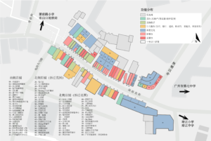
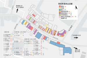
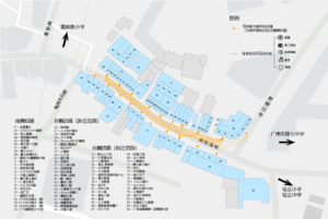
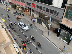
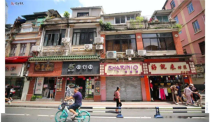
In September 2020, Guangzhou city government released an opinion draft to ask for public inputs for the plan to demolish Miaoqianzhi ‘jie’ and Shuqian Road to build a large interchange metro station – Shuqian Road Station in the historic old town area in Guangzhou, China. The draft raised huge public debate and the city conceded on leaving the Shuqian Road intact, but still decided to demolish Miaoqianzhi ‘jie’. While Shuqian Road is more difficult to demolish due to the existence of a large public library and Chenshuren memorial hall, Miaoqianzhi ‘jie’ is a mixed-used historic street with buildings and small businesses dated back to 1910s, mainly serving the local neighborhoods. Miaoqianzhi ‘jie’ also borders the Xinhepu Cultural District (a historically preserved area) and connects three local schools and a regional Children’s Palace (a public institution where kids take interest courses). Many stores on the streets have been open for decades and the streetscape is unique to the culture of the area. Therefore, Miaoqianzhi ‘jie’ has been a place of connections, memories, and cultural symbols.
Our project takes an action research approach and asks three research questions:
- How can we quantify the social impacts of the demolishment, from the perspectives of social networks and place attachment?
- How can we re-assess the “benefits” of transit connectivity from the perspectives of the locals?
- How might this research help promote a more civic-centered, well-rounded outcome for the street, even if we cannot stop the demolishment?
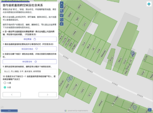
We conceptualize the social impacts as the inability to transfer daily life activities, maintain current social networks, and relive memories. We designed a spatially embedded survey through the Maptionnaire platform, where citizens can leave marks on the maps that highlight their visits to various places on the street and comment on the trip purpose, trip companion, and the replacement for the visit if the place is demolished. We also allowed citizens to share concrete memories, how the demolishment will impact their personal lives, and suggestions of alternatives in the survey.
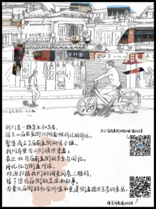
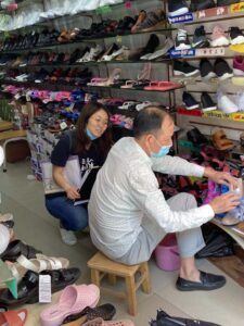
This research is embedded in a greater civic research movement that happened locally, organized by Miaoqianzhi ‘jie’ Research Group. The research group is founded by Friendly Cities Lab PhD Xiaofan Liang and has a Chinese WeChat account that published work conducted by research volunteers. So far, the research group has produced 1) a full set of shapefiles for every store on the street, 2) an archive of the store type, name, address, year, and storefront photos, 3) a research report concerning the first round of survey distribution, 4) a pack of six postcards picturing Miaoqianzhi ‘jie’, 5) two oral history interviews, and 6) passenger flow and mode counts for a sampled period of time. See our annual report for the public and stakeholders in Chineses (庙前直街研究报告).


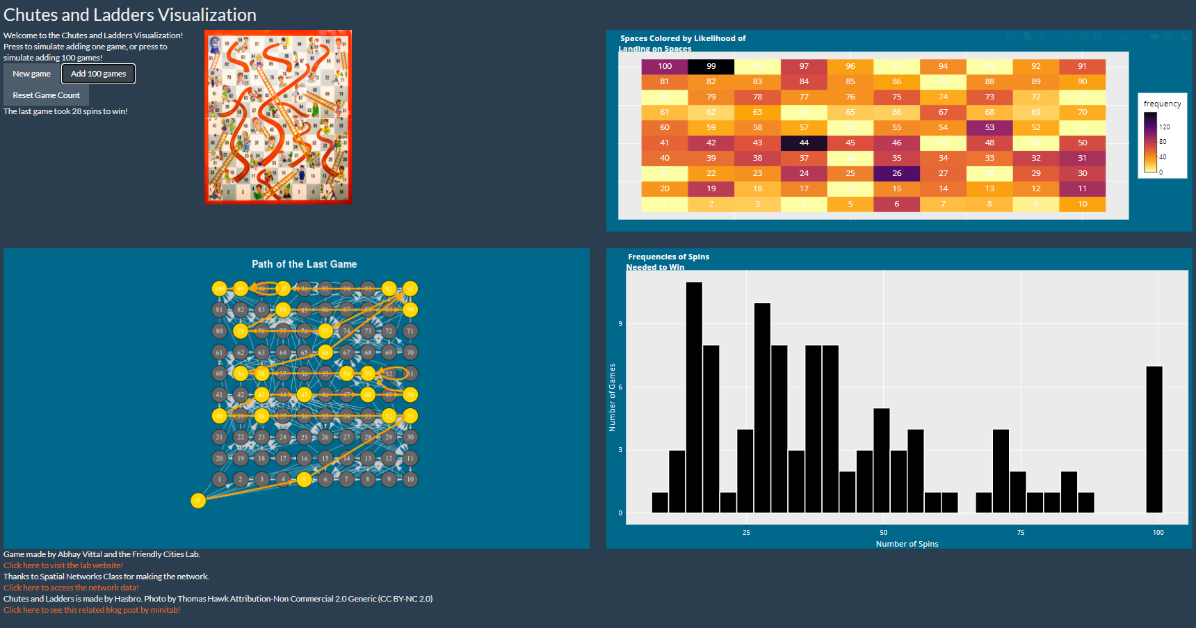
Chutes and Ladders Visualization
Summer intern Abhay Vittal created this fun interface for simulating Chutes and Ladders games. He used R Shiny to make the interface. There is a bit of lag time, but check it out!
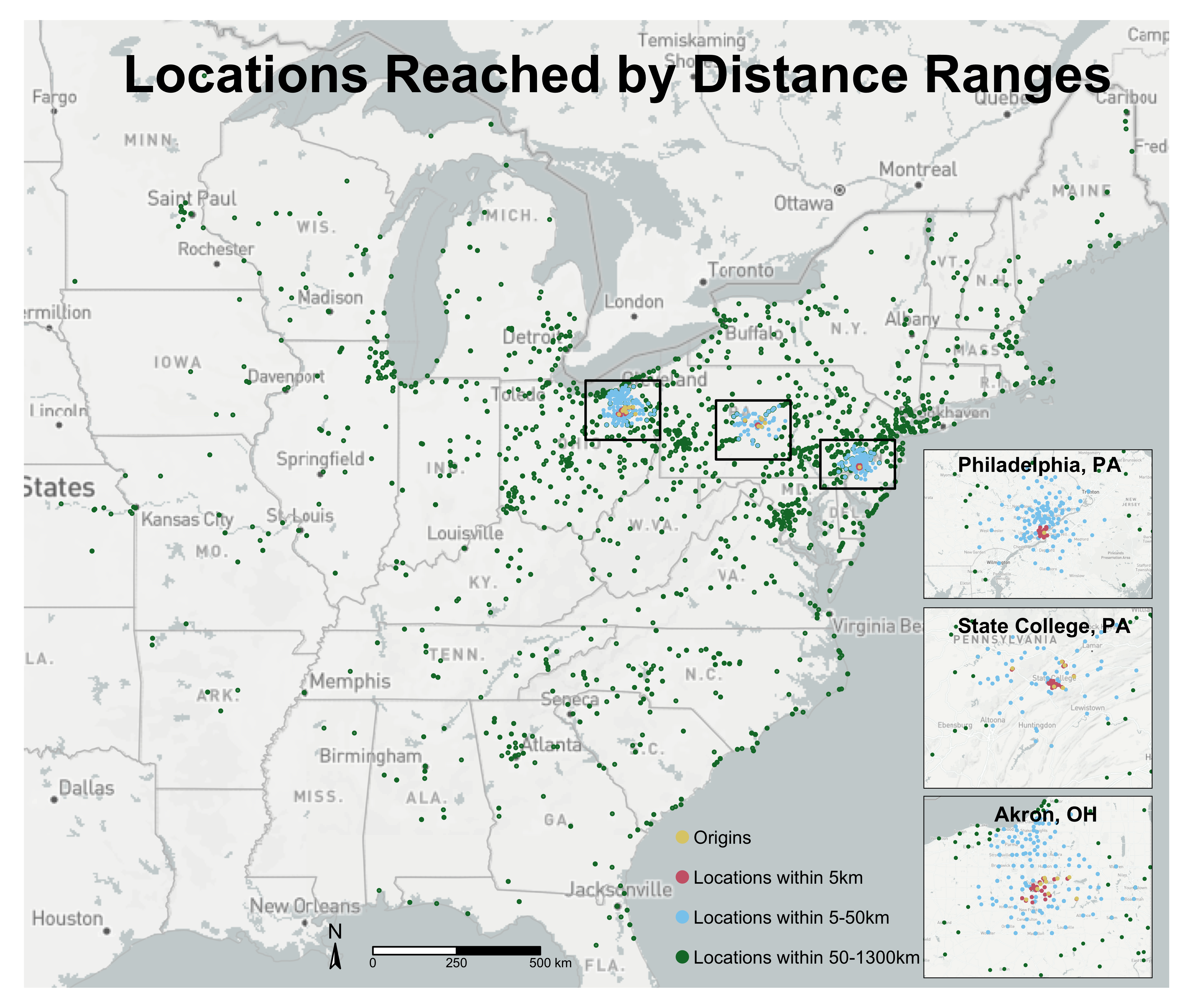
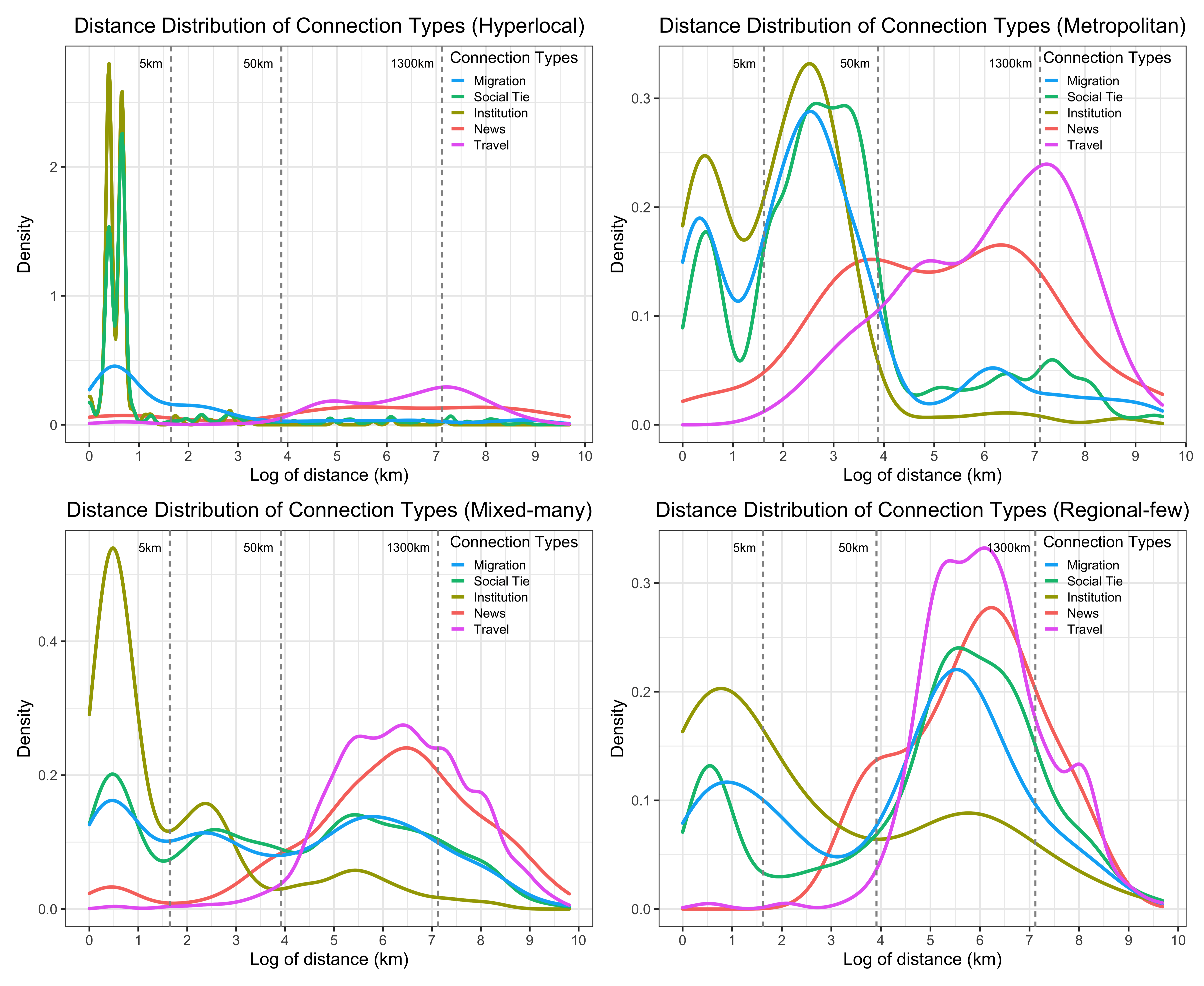
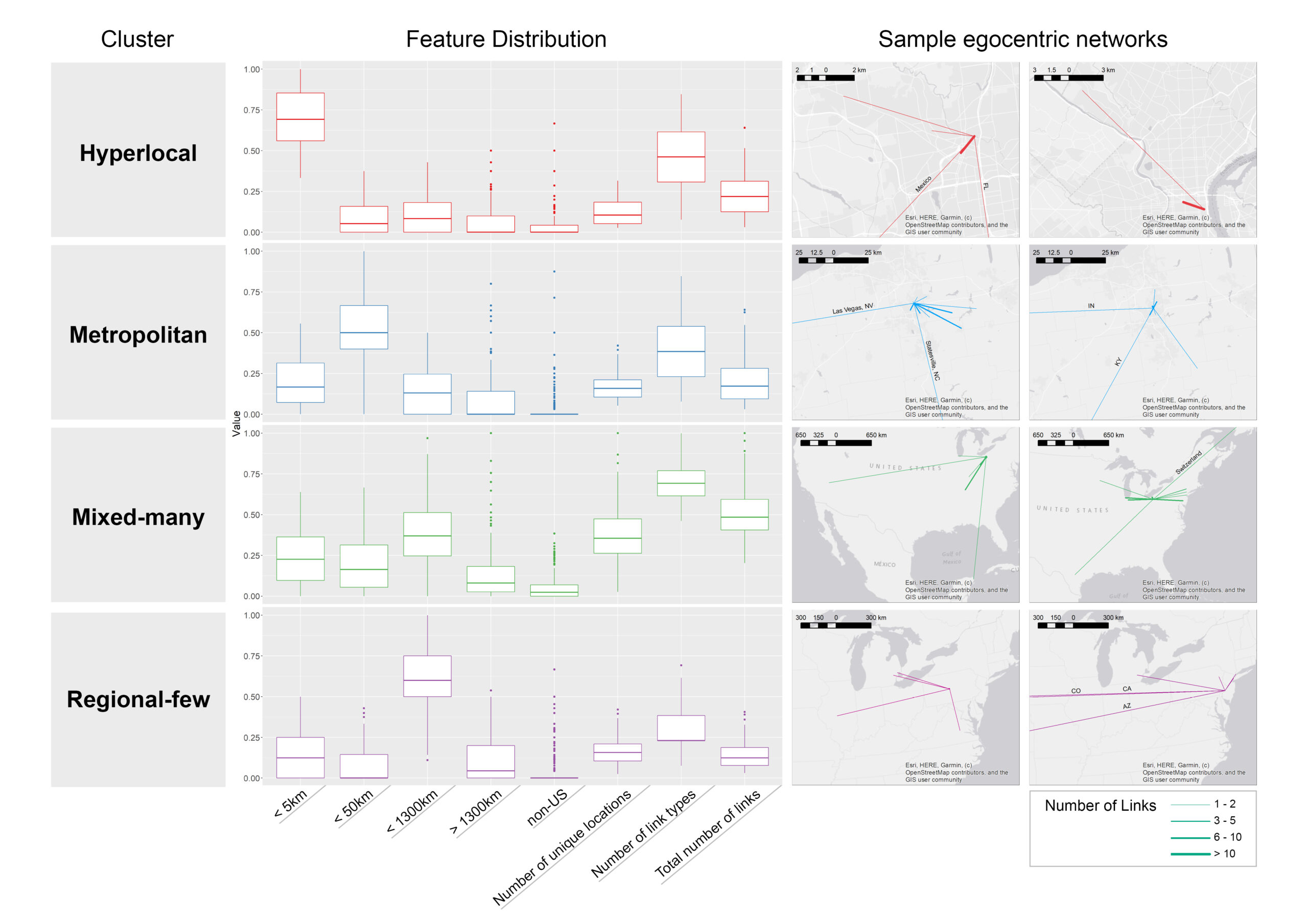
Characteristics of Jetters and Little Boxes: An Extensibility Study using the Neighborhood Connectivity Survey
Abstracts
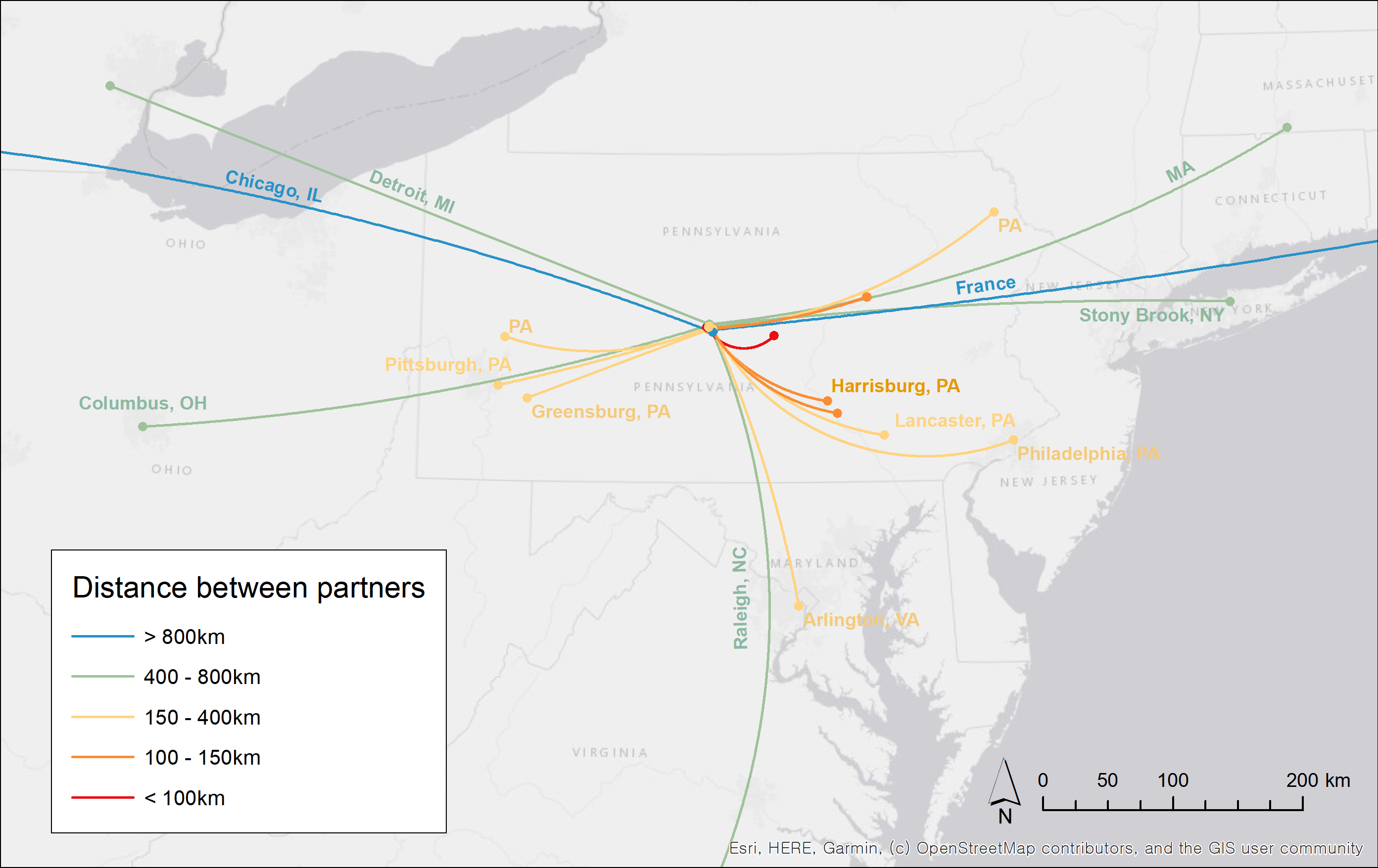
Individuals connect to sets of places through travel, migration, telecommunications, and social interactions. This set of multiplex network connections comprises an individual’s extensibility, a human geography term that qualifies one’s geographic reach as locally-focused or globally extensible. Here, we ask: are there clear signals of global vs. local extensibility, and if so, what demographic and social life factors correlate with each type of pattern? To answer these questions, we use data (n=950 (global sample); n=903 (in model)) from the Neighborhood Connectivity Survey (NCS), which was conducted in Akron, Ohio; State College, Pennsylvania; and Philadelphia, Pennsylvania, USA. Based on the location of a variety of connections (travel, phone call patterns, locations of family, migration, etc.), we found that individuals fell into one of four different typologies: 1) Hyperlocal, 2) Metropolitan, 3) Mixed-many, or 4) Regional-few. We tested whether individuals in each typology had different levels of local social support and different sociodemographic characteristics. We found that respondents who are white, married, and have higher educational attainment are significantly associated with more connections to a wider variety of places (more global connections), while respondents who are Black/African American, single, and with high school (or less) educational attainment have more local social and spatial ties. Accordingly, the urban poor may be limited in their ability to interact with a variety of places (yielding a wide set of geographic experiences and influences), suggesting that wide extensibility may be a mark of privileged circumstances and heightened agency.
This paper is published in the special issue: On the Role of Space, Place, and Social Networks in Social Participation in Social Inclusion.
Here is the link to our open-access manuscript: Characteristics of Jetters and Little Boxes – An Extensibility Study Using the Neighborhood Connectivity Survey
Here is the link to our survey. Neighborhood Connectivity Survey . Our survey data is open to sharing by request. Please contact clio@gatech.edu if you are interested.
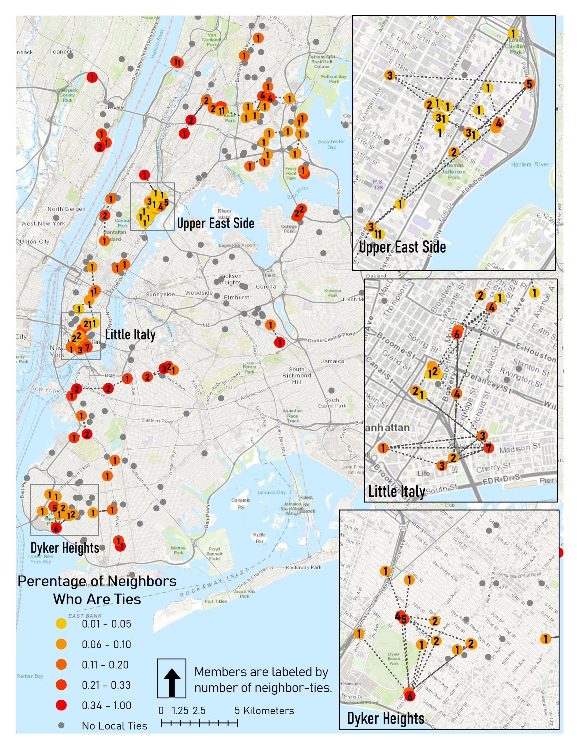
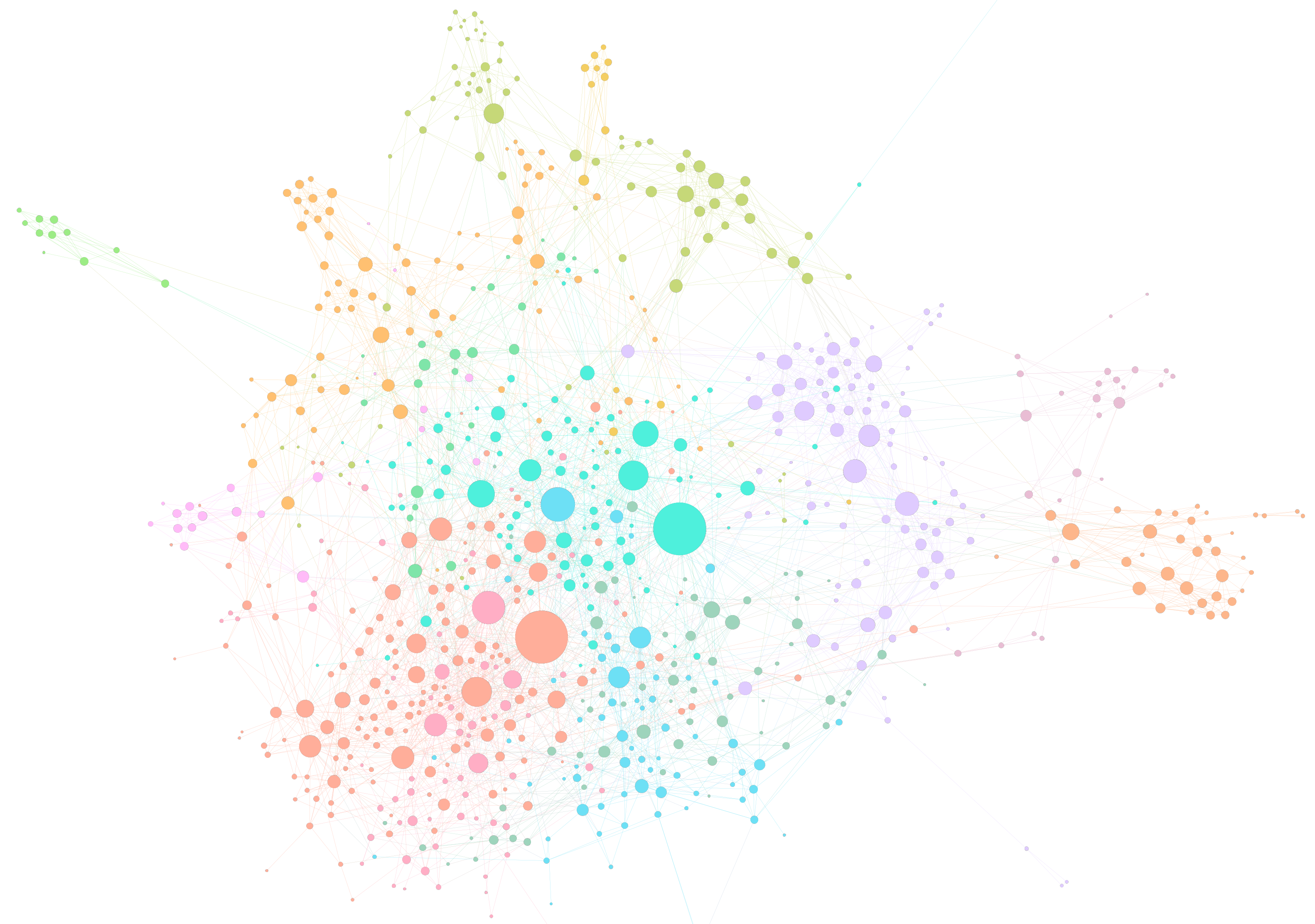
To Racketeer among Friends: Spatial Features of Criminal Collaboration in the American Mafia
The American Mafia is known as a violent network of criminals engaged in drug trafficking, violence, and illegal activities. We analyzed a spatial social network (SSN) of 680 Mafia members where connections represent `known associates’ found through a 1960s federal crime investigation by the U.S. Federal Bureau of Narcotics. Members are geolocated to a known home address, and span across 15 major U.S. cities, concentrated in New York City. We ask four different research questions related to family, power, and coordination strategies.
Q1: Do families tend to live in clusters or distributed locations?
Q2: Do criminal associates tend to live near one another and are nearby members likelier to be associates?
Q3: Are high-degree members found near their family centers, high-income areas, or near strategic physical features?
Q4: Does the network exhibit efficiency in geographic space?
The methods we used include:
| Method (Research Question) | Question |
| Cluster/Cluster Matrix (1) (new!) | Do tight-knit networks cluster? |
| Network Density Hotspot (2) (new!) | Are spatial neighbors connected? |
| Node Role GIS Analysis (3) | Are high-degree nodes in special locations? |
| Route Factor Diagram (4) | Are network-distant ties dispersed? |
| Network Flattening Ratio (4) | Is the network spatially efficient? |
See: Andris C, DellaPosta D, Freelin B N, Zhu X, Hinger B and Chen H (2021) To Racketeer Among Neighbors: Spatial Features of Criminal Collaboration in the American Mafia. International Journal of Geographical Information Science, DOI: 10.1080/13658816.2021.1884869. [PDF]


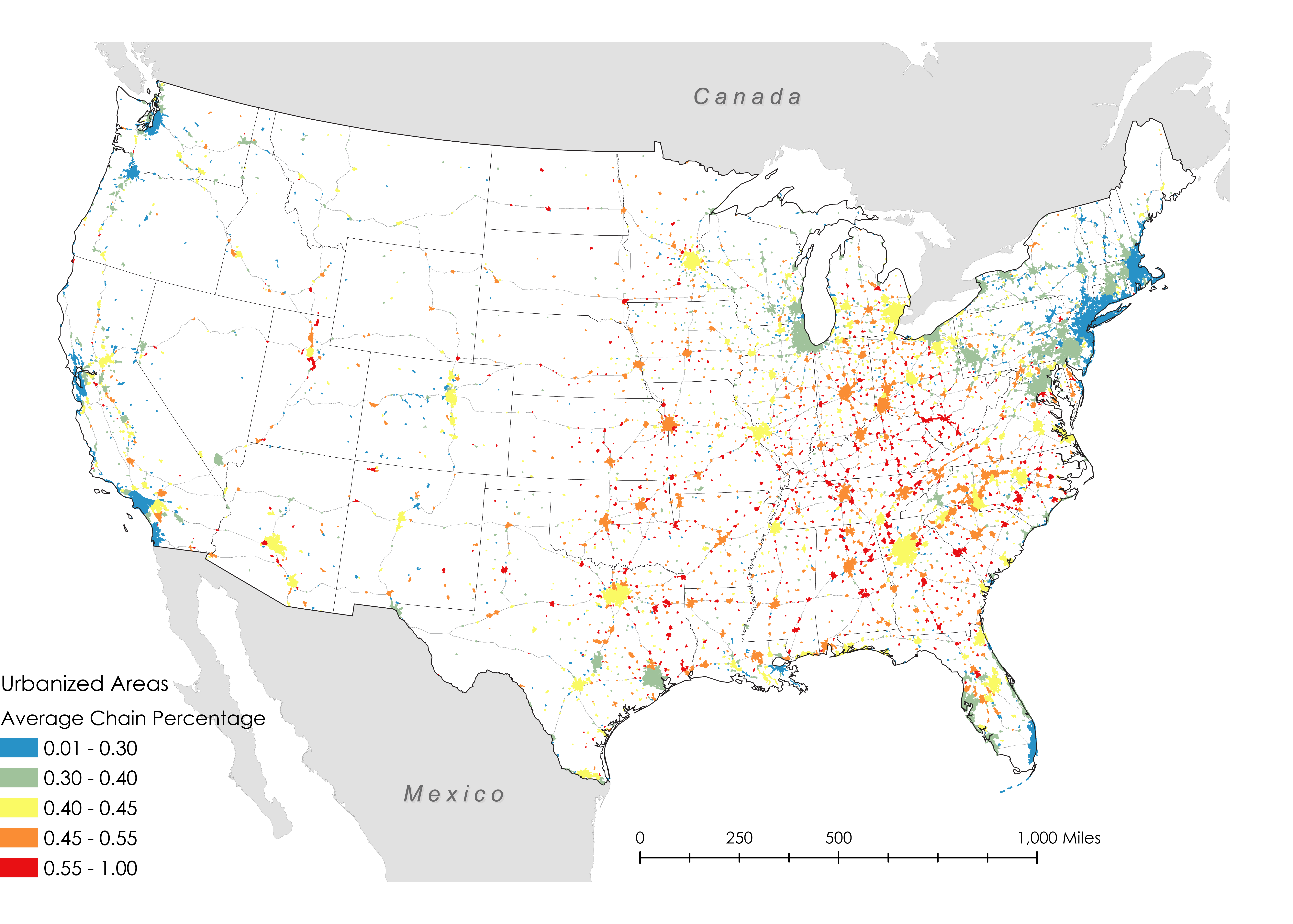
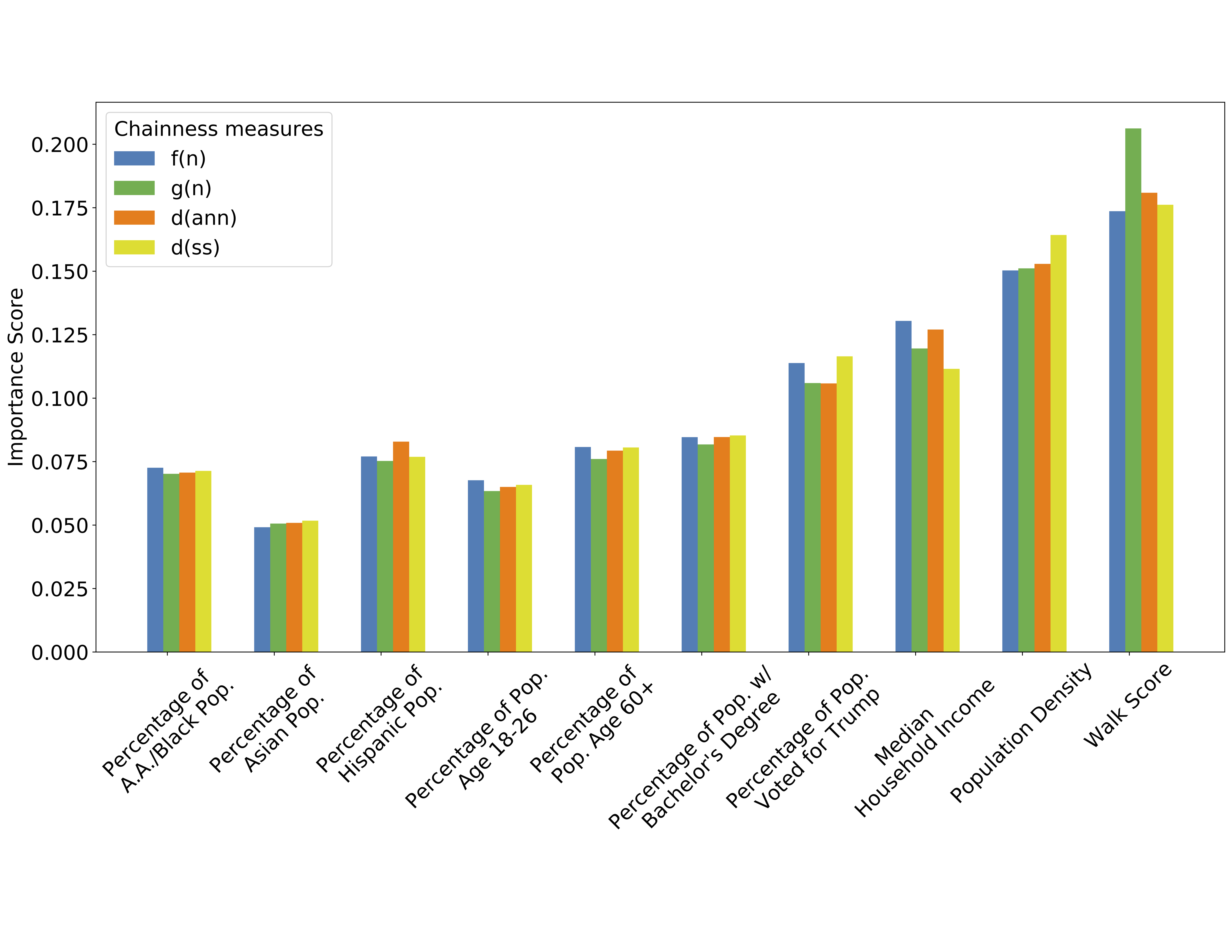
Measuring McCities: Chain and Independent Restaurant Location in the United States
In this research, we explored which (types of) places have an independent food culture and which resemble McCities: foodscapes where the food offerings in the landscape can be found just as easily in one place as in many other (often distant) places. We used a dataset of nearly 800,000 independent and chain restaurants for the contiguous United States and defined a chain restaurant using multiple methods. We performed a descriptive analysis of chainness prevalence at the urban area and metropolitan area level. We also identified socioeconomic and infrastructural factors that correlate with high or low “chainness” (a value indicating the likelihood of finding the same venue elsewhere) by combining a random forest model and linear regression. We then examined chainness variation across census tracts with similar sociodemographic values. Using common GIS operations, we evaluated the likelihood of finding chain restaurants of nearby water bodies, coastlines, and highway ramps.
We found that car-dependent small towns, low walkability, a high percentage of African American residents or Trump voters, college towns, and close distance to highways were associated with high chainness. These places tended to be prevalent in the Midwestern and the Southeastern U.S. Independent restaurants were associated with high pedestrian walkability, high population density, Asian, Hispanic and majority-White neighborhoods, tourist areas, areas with urban professionals, and retirement communities. They were also found in coastal cities and waterfronts. These findings, paired with the contribution of a method that quantifies ‘chainness’, opens new pathways for studying landscapes through the lens of commercialism and the service economy. See Environment and Planning B article. See Draft Manuscript. Play with the map!

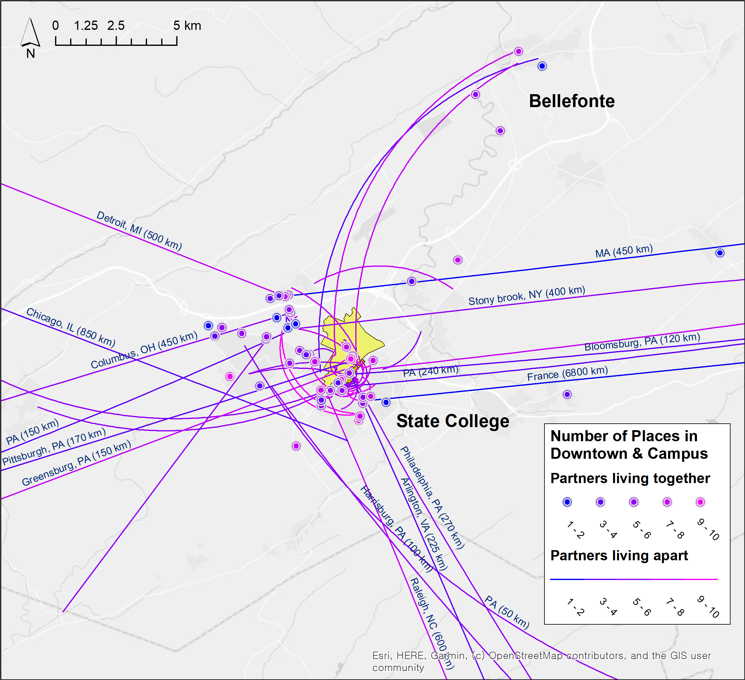
Urban Planning for Romantic Relationships <3
We investigated what romantic relationships need from the built environment and how these relate to urbanism principles. Our research questions were threefold: (a) Where do couples spend their quality time and what are the characteristics of these places? (b) Does distance between these places and the couples’ residences affect usage? (c) How does State College, PA support romantic ties and how can it be improved? We conducted an online survey of 124 couples in the State College, PA area, and analyzed these data using frequency statistics, OLS regression, and qualitative coding. We also created maps of the relationships’ approximate locations and measured how their locations affected their activities.
We found that restaurants and the outdoors/recreation were most important for sustaining relationships. Couples frequently emphasized activities involving nature and sports/leisure time and rarely mentioned dinner parties, nightclubs, country clubs, or religious facilities. Couples reported that the town satisfied their relationship needs, especially in terms of safety (i.e. well-lit areas and pedestrian-friendly environments). We think this research can be useful during the COVID-19 pandemic, as cities try to support social ties amidst the closure of third places and social activities. Post COVID-19, it may also help inform which facilities to prioritize in terms of opening decisions post-pandemic.
Andris C and Lee S (2021) Romantic Relationships and the Built Environment: A Case Study of a US College Town. Journal of Urbanism: International Research on Placemaking and Urban Sustainability, 1-22. (Online first). [PDF] and [Supplementary Information]

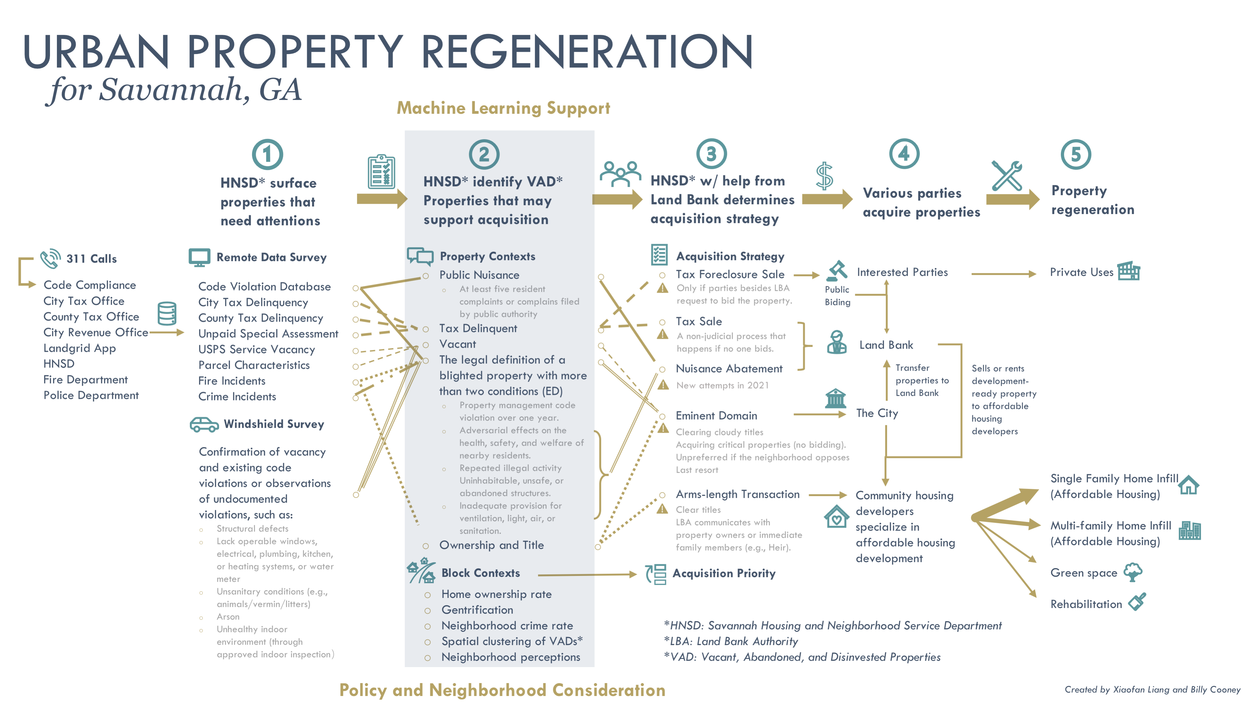
Savannah Blight, Civic Data Science for Equitable Development
Friendly Cities has a new collaboration with the City of Savannah to strategize decisions to address vacant and blighted properties in the community. Neighborhoods experiencing blight suffer from safety concerns and lower housing values, leading to suboptimal living conditions for already marginalized residents. Savannah’s Housing & Neighborhood Services Department also estimated that every blighted property bleeds $1300 of public funds annually. These funds are used to cover the unrecoverable costs of overgrown grass, litter, illegal dumping, securing open structures, and demolishing properties. In 2019, local voters approved the use of 10 million dollars to acquire and redevelop of at least 1,000 abandoned, blighted residential properties over the next 10 years to effect meaningful change in neighborhoods long neglected or exploited by profit-driven investors. However, strategizing which properties to intervene first and what kinds of interventions can be best applied for equitable development remains a challenge.
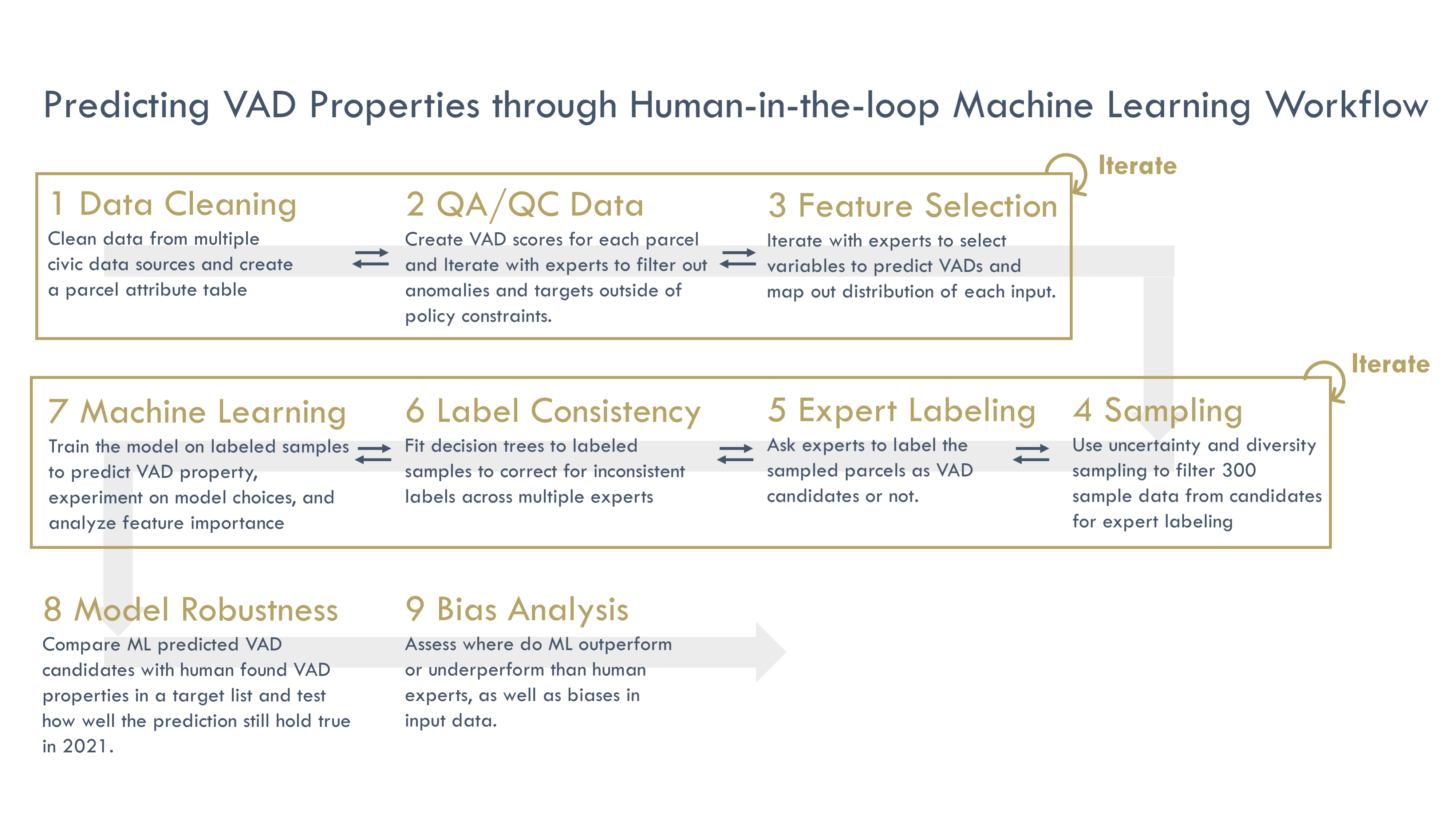
Our research revolves around developing a human-in-the-loop machine learning model to help the city identify vacant, abandoned, and disinvested (VAD) properties. The human-in-the-loop approach entails closely collaborating with the housing planners to identify areas for interventions, feature selections, active learning (diversity and uncertainty sampling techniques), and interpretable machine learning outcomes. We also compare our model outcomes with human-found VAD properties, check robustness with 2021 data, and conduct an empirical analysis to determine which neighborhoods may be subject to data bias. This project is funded by the Georgia Smart Communities Challenge 2020 jointly with Brian Brainerd of the City of Savannah. Graduate Research Assistant Xiaofan Liang is leading the analysis. The links attach media reports from Savannah government and Georgia Tech. See Xiaofan’s presentation at ACSP conference here Savannah_ACSP_presentation.

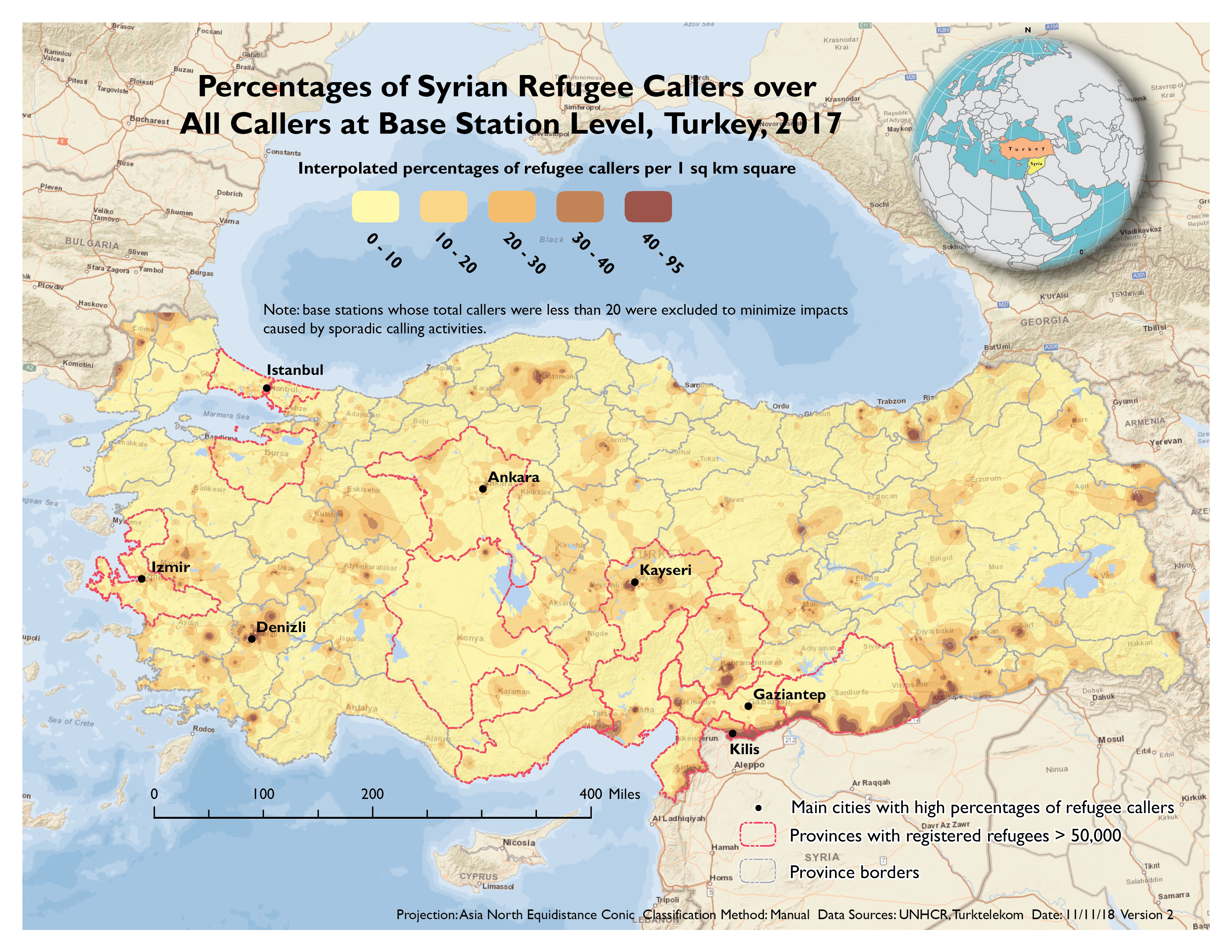
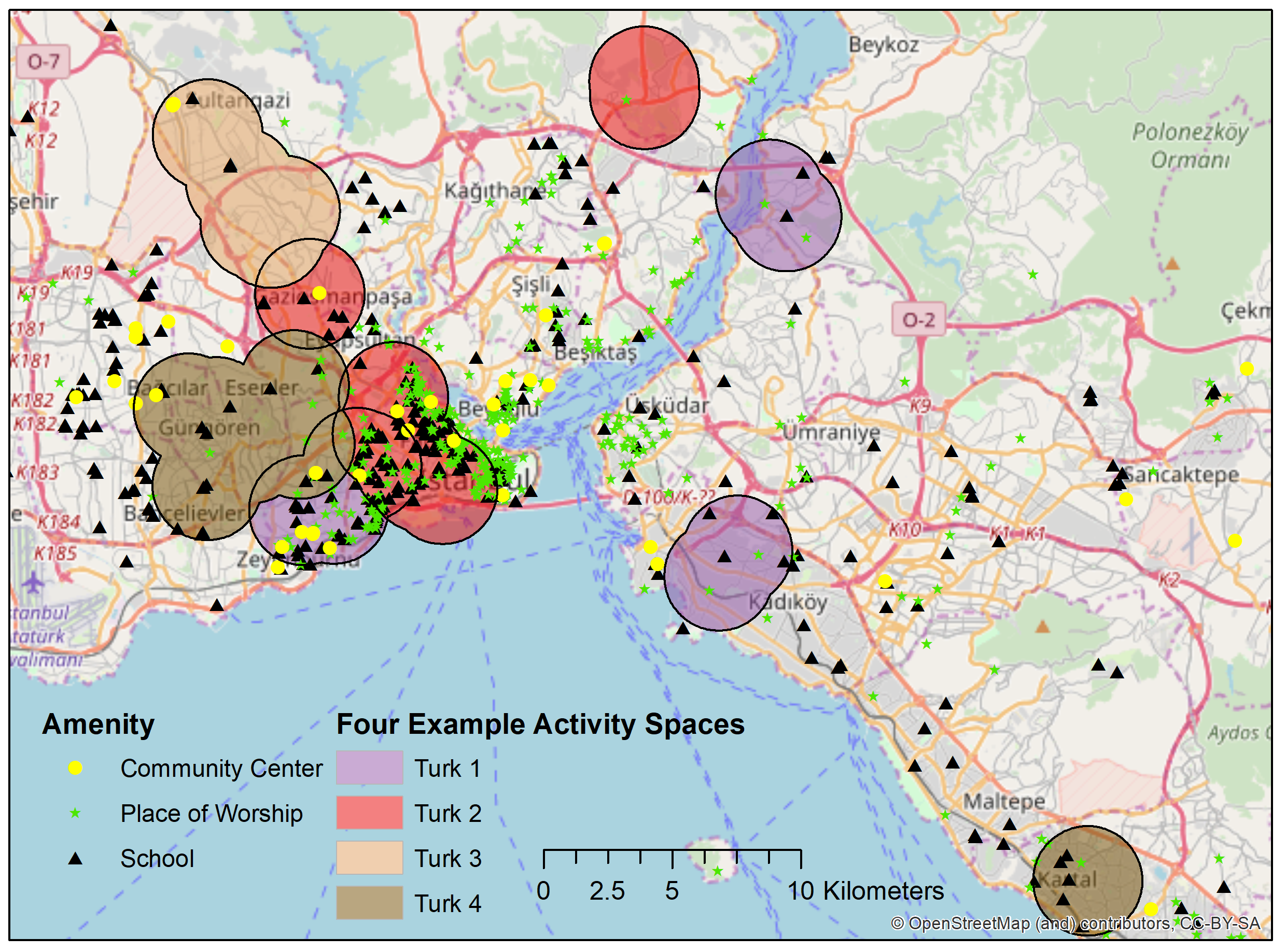
The Built Environment and Syrian Refugee Integration in Turkey: An Analysis of Mobile Phone Data
We use a large call detail record (CDR) dataset from mobile operator Türk Telekom to examine how refugees from the Syrian Refugee Crisis are integrating into Turkish society. We extract different types of callers from the social network: refugees who often call Turkish nationals, refugees who do not call Turks; Turks who often call refugees, and Turks who do not call refugees. We consider frequent phone calls between refugees and Turks to indicate high levels of bridging social capital for these users, and that refugees tied to Turkish nationals through calls have integrated into the Turkish society, economically and/or socially. We also assume that Turks who often call refugees are investing in creating these relationships (although these comprise a relatively small set of users).
We found few significant geographic patterns for refugees who were calling Turks often. However, bridging Turks were found to be located near infrastructural variables such as places of worship, schools, community centers, and social centers/facilities, more often than their non-bridging counterparts. These differences were strongest in locales with Muslim and Sunni Muslim places of worship. In these locales, presumably, refugees and Turkish nationals share common values and beliefs. Our results provide quantitative evidence suggesting the significance of social amenities and meeting places for face-to-face connection and social support for the livelihoods of refugees and refugee integration
Project Highlights
- Let’s go to the HippoHop: Mining Yelp Data for Relationships and Points of Interest
- Estimating Diversity at Points of Interest (POIs) in Atlanta, Georgia using Origin-Destination Trip Data
- Quantifying the Social Impact of Demolishing a Historic Street for A New Metro Station: Evidence from Participatory GIS Survey in Guangzhou, China
- Chutes and Ladders Visualization
- Characteristics of Jetters and Little Boxes: An Extensibility Study using the Neighborhood Connectivity Survey