Restaurant Chainness
Independent restaurants are important for placemaking, cultivating place identity, and creating local culture. We explored which (types of) locales have an independent food culture and which resemble McCities: foodscapes with chains. We used a dataset of nearly 800,000 independent and chain restaurants for the Continental United States and defined a chain restaurant using multiple methods (notably, by the number of restaurants with the same name). We found that car-dependency, low walkability, high percentage voters for Donald Trump (2016), concentrations of college-age students, and nearness to highways were associated with high rates of chainness. McCities are prevalent in the Midwestern and the Southeastern United States. Independent restaurants were associated with dense pedestrian-friendly environments, highly educated populations, wealthy populations, racially diverse neighborhoods, and tourist areas. Low chainness was also associated with East and West Coast cities.
New map (!!): Check out our new map here (not mobile friendly).
Dataset information and download data: Github Site
Popular press: Bloomberg MapLab and Washington Post
Images: [Urbanized Area Pct Chains][Metro Area Pct Chains][Metro Area Frequency]
Reference to paper: Liang, X., & Andris, C. (2022). Measuring McCities: Landscapes of chain and independent restaurants in the United States. Environment and Planning B: Urban Analytics and City Science, 49(2), 585-602.
Old Map Below
POI Explorer for Relationship Types
This map helps users explore points of interest by relationship type that it serves. See the scientific paper here. This work was presented at URBCOMP ’22.
VIEW AND EXPLORE THE ONLINE MAP HERE!

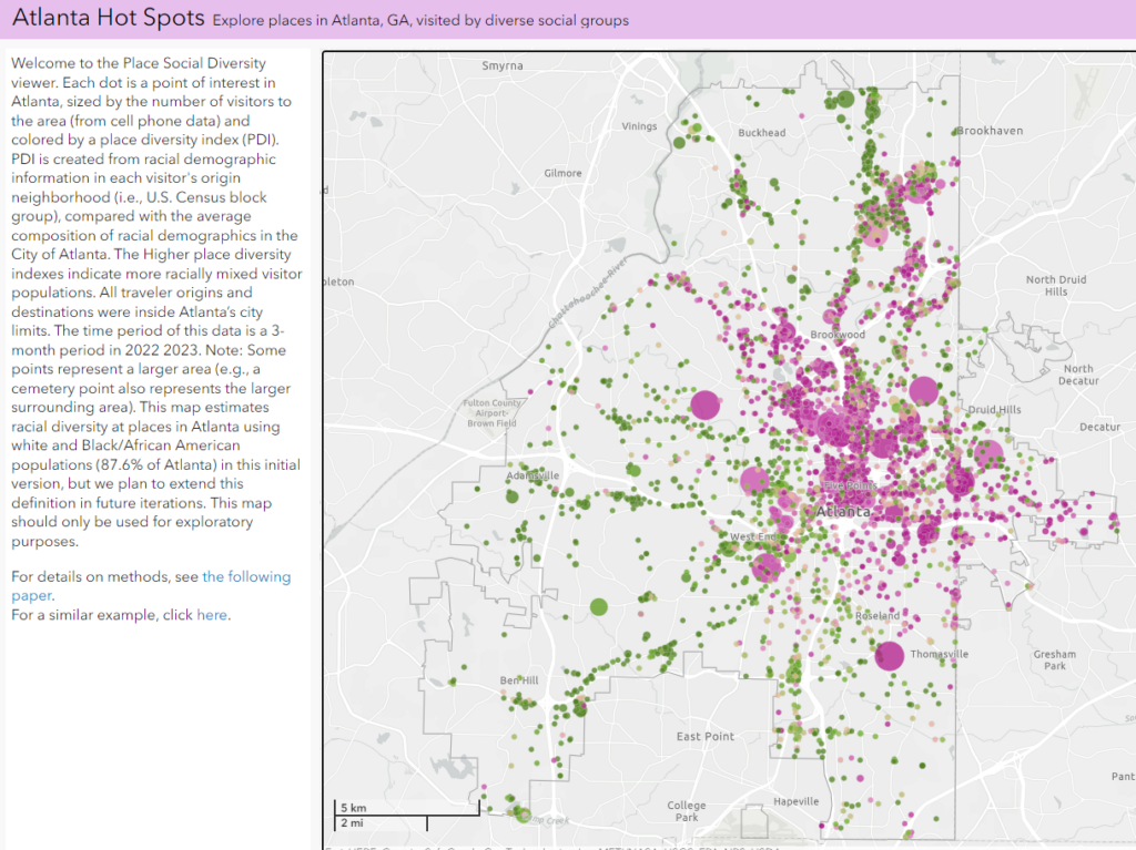
Atlanta’s Destinations by Popularity and Racial Diversity of Visitors
VIEW AND EXPLORE THE ONLINE MAP HERE!

Reference to paper: Lee S and Andris C (2023) Place Diversity: A New Attribute for Points of Interest, Presented at CUPUM 23 in Montreal, Canada.
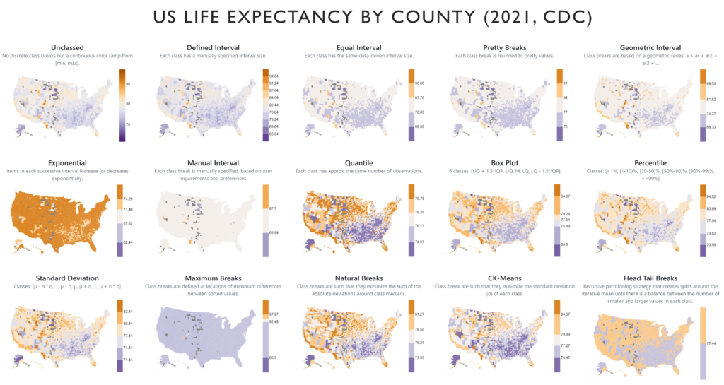
Data Binning and Map Exploration Tools

Key Tools:
–Observable Notebook and JavaScript Package
–Interface for Exploring Binning Methods and using Resiliency
Reference to paper: A Narechania, A Endert, and C Andris (2023) Resiliency: A Consensus Data Binning Method, Short Paper, GIScience 2023, Leeds, UK.
Slides: Download presentation slides here.
Atlanta Boundaries on Google Maps
Atlanta Area County Google Map | Atlanta Area Zip Code Google Map | Atlanta City Council Districts Google Map
NCAA Athlete Hometowns
Reference to paper: Andris C (2018) Measuring Geographic Pull Power: A Case Study of College Athletics. The Professional Geographer. 70(3): 476-490. Download the data.
What’s Inside my AirBNB: Analysis of 50,000 Living Rooms
Reference to paper: (and data): Liu, X., Andris, C., Huang, X., and Rahimi, S. (2019) Inside 50,000 living rooms: an assessment of global residential ornamentation using transfer learning. EPJ Data Science, 8:4.
Check our github site for updates on packages and code.
